
PA Route 873 (1260.5) to Delps Spring/Trailhead 1270.8 (10.3 miles, 245.35 total miles)
It was hard to fall asleep last night, after I was done writing about my day I had all sorts of adrenaline going thinking about the wonderful day I’d had, and the big climb up ahead first thing in the morning. I had heard it was tricky from a few sources at this point, and I felt a little anxiety about it.
Listening to the Chamber of Secrets audiobook helped me fall asleep, and I thought how funny it was that snakes are so prominent in that book, and equally prominent in the state of Pennsylvania, where I’d been hiking the whole time I’d been reading that book both in my head and on actual audiobook.
I haven’t been bored in the woods in ages, so consumed with making my way over the rocks, past the snakes, and taking in the views. So I had only reached the part where they enter the chamber itself. I woke up about an hour after I feel asleep to use the bathroom, around midnight, and relished the fact that I could use indoor plumbing to do so.
Squeak had said the door was open all night, so I went in and was surprised to see that she was still up. She had a bit of a cold, so was taking a Covid test to be safe. I ended up sitting and chatting with her for over an hour about all sorts of stuff, things like family, trauma, ancestry etc. It was a really great conversation and I couldn’t believe it was quarter after one when I went back to my tent.
In the morning, I sure wanted more sleep, but I made myself get up around 6 AM because I had a few more miles to do today than yesterday, plus I knew that big climb would slow me down. I packed my tent and bag, and put on laundry so clean that, as Squeak had said it “made me smell like a day hiker” (to a backpacker, day hikers smell like soap, laundry, detergent, perfume, or basically anything that smells nicer than us).
Squeak and her husband Dave gave me a delicious cup of coffee, and even a couple frosted brownies, my kryptonite. I ate one as part of a nutritious breakfast, and packed the other away. I sat and talked with them for about another half an hour, until it was about time to get back to the trail.
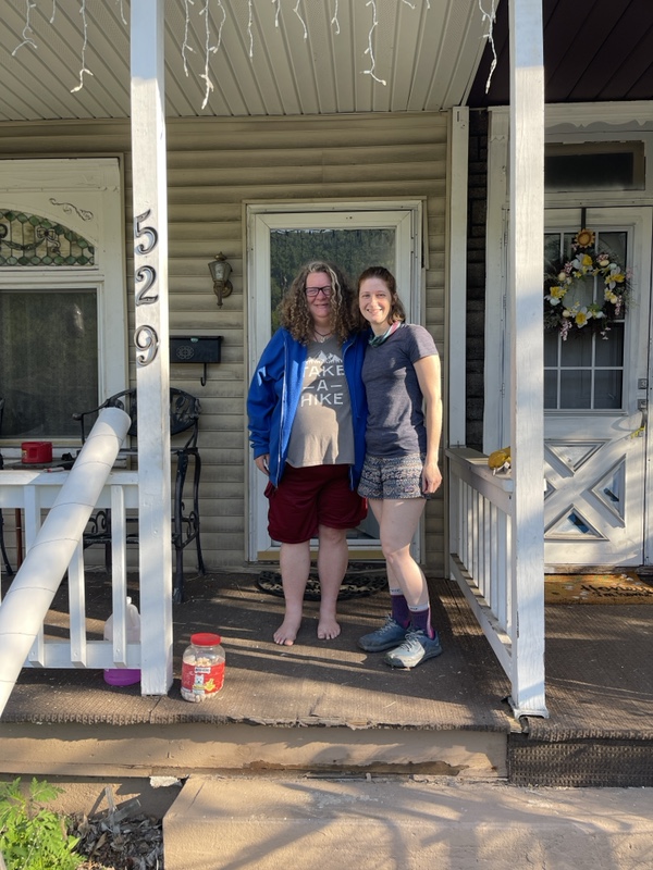
Dave dropped me back off in the little parking lot that I had left at the night before, and we talked about cars on the way there. He waved away my offer of a few bucks for gas, since it was so close to their house.
The amount of kindness I have received while I’ve been out here for just a few short weeks has blown me away, and I try to make sure that I take nothing for granted and always offer something in return. Especially because last time I really didn’t have much to offer, but if I can’t pay it back I certainly look for opportunities to pay it forward.
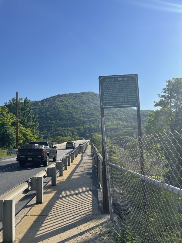
I crossed Lehigh River over the bridge, and did a little road walking before getting back into the woods. In the parking lot I had put on copious amounts of sunscreen and bug spray, and after the road I went through my morning ritual of untying and re-tying my shoes, never knowing how swollen my feet were going to be in the morning.
It was about 75° and sunny, and it would be 85 by the time I had made it up the mile climb. The ascent started in the woods, and it got quite steep right off the bat. I had taken out my sunglasses, because I knew the trail was about to get very exposed.
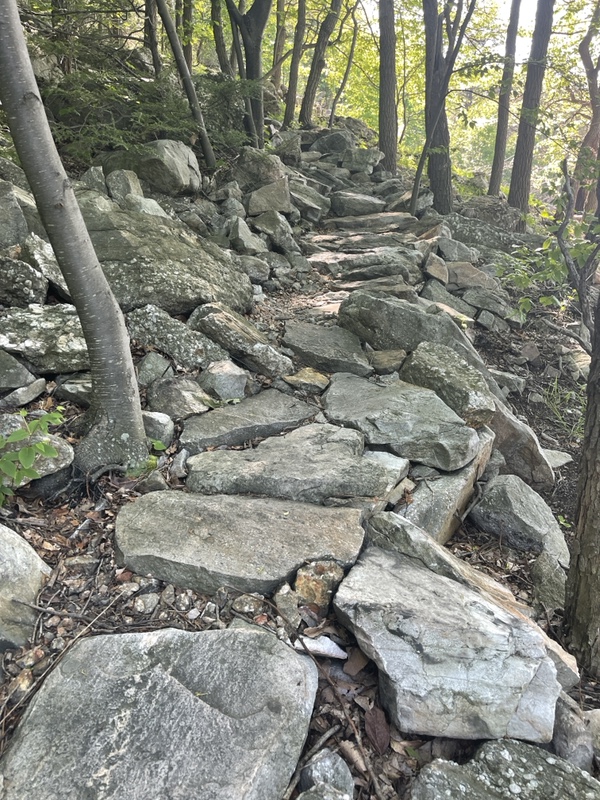
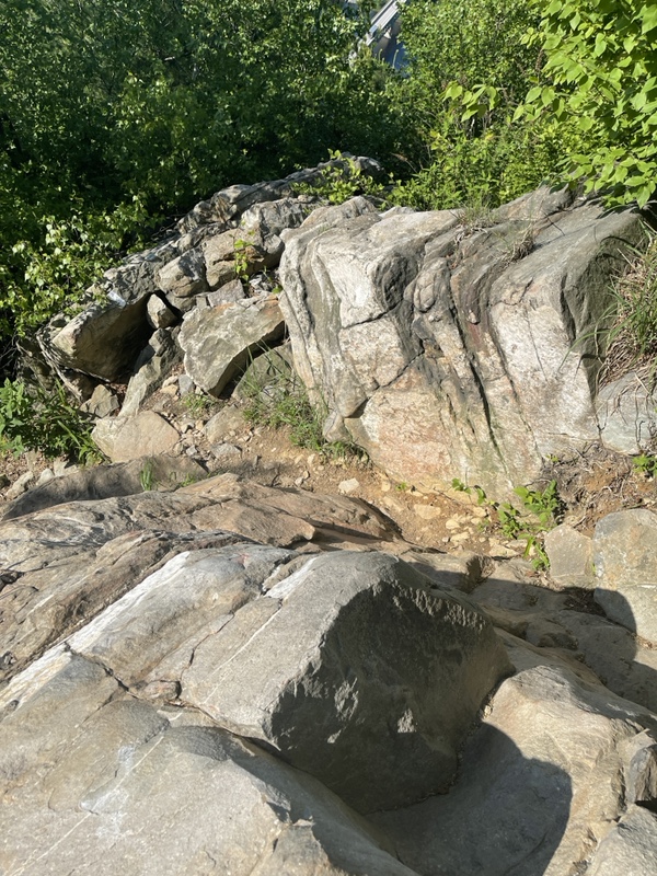
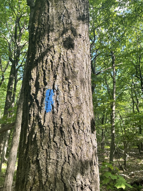
I was glad I had, because after I got a little turned around on the wrong trail and backtracked, the sun was out in full force on me. Squeak had told me the best way to climb the mountain was to follow the white blazes exactly where they go. So that’s what I did, and the trail became steeper and steeper until I was doing four-point climbing.
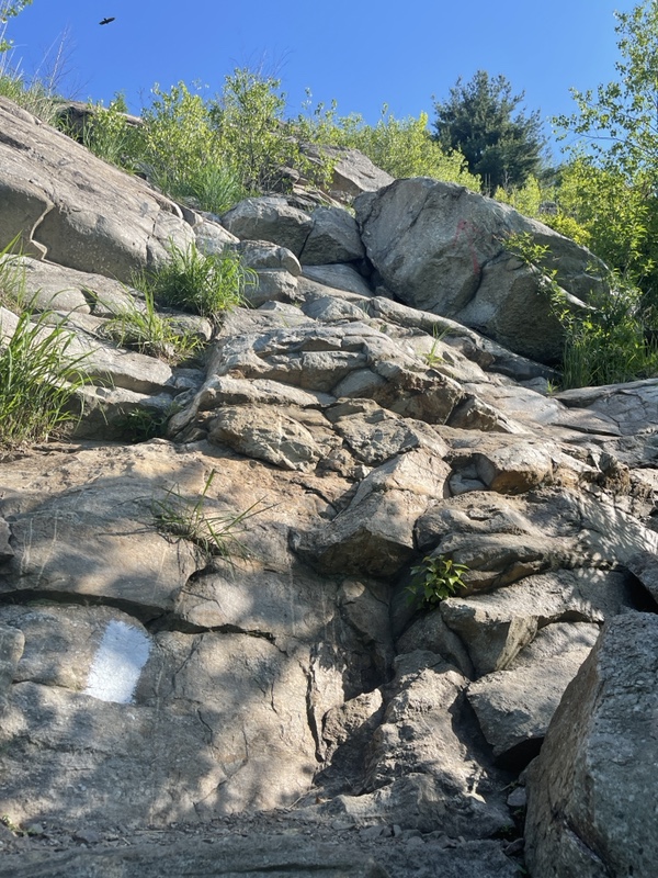
Four point climbing is where you either loop your trekking poles around your wrists or you chuck them down or up the trail ahead, and use all four points to climb, hands and feet. It was a little treacherous, because I had to climb up some ledges and I never knew if there was going to be a snake waiting for me up above.
At one point I did as Squeak suggested, and took my pack off and put it on the ledge in front of me before climbing up. Once I was up on the ledge my phone promptly fell back down from whence I came. I got very lucky and it only fell a few feet and not down the entire mountain.
I had gotten away with keeping it sticking half out of my hip belt pocket so far, a slightly precarious position but one that had been working till now, and for the next bit of trail I tucked it in my side pocket behind my water bottles to keep it safe and out of reach. I don’t know who reading this blog needs to see more pictures of rocks at this point anyway, but if you do feel free to personally write to me and tell me why you enjoy my pain.
After quite a few spots of intense climbing, I made it to the other side of the ridge which was less sunny fortunately, but there was lots of shale that was uneven and unstable as I walked across. I was already very sweaty and gross from the exertion, but I still smelled like fresh laundry and that was a bonus.
After a while the crazy climb was over, and the trail got much easier and sort of like gravel as it easily wound its way up to the top of the ridge. I have been making little videos for myself here and there to watch back later, and I started recording one for a few minutes, getting very emotional as I talked to myself about how I felt I was finally living my purpose doing this writing, hiking the trail, how it’s such a different experience seven years later, and how this may end up being the one of the best decisions of my life.
I definitely was crying a little, and rounding a corner up ahead I saw a couple day hikers hanging out right off the trail. I stopped my video, and when I climbed up to them I apologized for my ramblings alone in the woods.
They seemed in their late teens or early 20s, Johnathon and Josh, and they seemed really nice. I told them a little bit about my hike, and Johnathon said that he had always wanted to do some sections of the AT. I told him I couldn’t recommend it enough, but maybe start up in New Jersey or down in southern Pennsylvania to stay out of the rocks for a bit just starting off.
I moved on, and 2/10 of a mile I found the view that Squeak had told me about, and I walked up a little rise to do the Squeak Challenge. The challenge is to see if I could spot her house from the ridge, and I’d been thinking about this, because I love a good challenge.
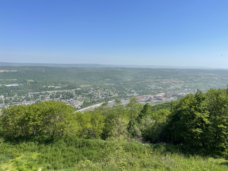
I thought I saw it right away, but made sure I counted the number of neighbors and looked for landmarks. To my surprise, after I sent Squeak a picture where I circled my guess, I got it right. I felt very proud of myself.
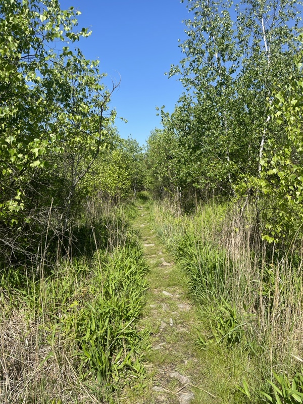
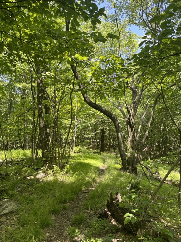
After that, the trail was grassy, soft, and flat-ish as I walked along the ridge, with plenty of view to my left. Fallout and another northbound hiker passed me from behind, and I listened to a podcast for a little bit as I hiked, having more battery than I’d expected after charging last night. I saw the other hiker was using his umbrella to hide from the sun on the very exposed ridge, so I finally tried the same with mine for a bit, and it really did make a difference in terms of comfort. My own little shady spot.
Since I was planning on just under 16 miles that day, I had decided to split my breaks into every 4 miles. So right before the first powerline I took a break to let my feet air out, had some water, and ate some snacks. I had the apple that Mr. Mooney had given me yesterday which, true to his word, was about the crispiest and best apple I’ve ever had. The sugary brownie was so good I almost cried, and I realized I didn’t smell like fresh laundry anymore.
The place I had taken my break was a little campsite right before the powerline, and it was nice and breezy. As I resumed my hiking, I kept my umbrella open through the powerline section, which was very exposed. Back in the woods, things got rocky enough that I had to really watch my feet again. There was a descent down to a road outside of Danielsville, small but steep, and going down to it I realized the heat and the sun were soaking the energy right out of me.
I had left Squeak‘s with 2L liters of water and the iced tea from the day before, and I had already gone through a liter by the time I hit the road. The water cache that had been there was sadly empty, but I filtered my other liter of water since it was in the dirty water bottle and used some of it to make what I hoped was an electrolyte drink. I knew it had caffeine in it, but the packet had no writing on it since I’d taken it out of the box in Waynesboro.
There was another short but very steep up after the road, where I caught up to a couple section hikers I had passed earlier in the day. We talked about how the next water is either off the trail at the Blue Mountain ski resort ahead, or 4 miles up and .4 off the trail. The last time it was this hot I had hiked through Cumberland Valley where and there was almost no water as well. I was having a knack for hitting very dry spots on very hot days. It was cooler and less buggy on the ridge than in the valley, but the ridge made up for it in rocks.
The two section hikers have 90 days to hike and are planning on trying to get to Katahdin from Harpers Ferry. Their names are Gadget and Ironheart, and Ironheart is a young female who had never gone hiking longer than a mile in her life before coming out to the AT.
I was very impressed, especially when they told me that they had done the huge ascent I had done today last night in the dark around midnight. That sounded incredibly sketchy and I was glad they’d made it okay. They didn’t know about the ascent, and I suggested they get the Far Out app so they can stay more informed.
They also told me how they had to take a Lyft into Palmerton, pay for somewhere to do their laundry, and walk all the way back out of Palmerton to the trail. Without the app, which has comments by other hikers, they had no information about shuttle drivers or Squeak even. I felt an incredible surge of gratitude for the good fortune that I had been gifted when I considered what their day had looked like yesterday compared to mine.
My ankles were in a fair amount of pain already by this point. PA was kicking my butt, and I reflected how starting my last flip-flop attempt in southern Virginia had been a lot different than hiking through with these rocks so early on. Southern VA has much more elevation, but these rocks are no joke towards the end of the PA.
I wondered how the rest of the flip floppers felt about it who hadn’t hiked any of the AT before. The last time I was almost 300 miles into my hike, I was probably somewhere in the Shenandoahs, a very easy going section with campgrounds, lodges, and lots of water all around.
The nice thing was that I knew this was my one long day of the week, at least till Thursday, and I had two nice short days till DWG after this. It was really my first time planning multiple days in advance on this trip, and I realize it’s kind of nice for my morale and knowing where I’m going.
I ended up stopping at a tent site, about 2 miles short of where I wanted to stop, for lunch at the next powerline. It was already 2pm and I was only about 7 miles into my day. The PA rocks had really killed my speed. I think I was also realizing that the Altras are so minimalist that they offer no ankle support, so I feel like I have to tie the laces tighter to make up for it and then my feet are too compressed when they swell. I’m really hoping to maybe get some new shoes at Delaware Water Gap.
I had some cheese and pepperoni, then shoved M&Ms into my mouth mechanically, needing the quick energy of the sugar because the sun was just sapping it out of me.
I saw Gadget and Ironheart pass by on their way to the next spring, which was still 3.3 miles ahead. After a 30 minute break, I continued on as well. The day was turning out to be a rough one.
I had finished just about all of my water, but I still had the small bottle of iced tea left to get me to the spring if I needed.
I had given a quarter of my last liter to a section (day?) hiker who had a whole story about how he lost his stuff. He said it was down by the road with fruit in it and he was dehydrated. I asked if he knew about the resort that has water and he said yes. After the water, he turned and hiked right back into the forest, completely off the trail instead of going for his pack or water. I’d noticed scratches all on his arms and legs, and thought he had a weird energy about him.
I saw somebody going southbound who was kind of doing a flip-flop too but in a different order, in three sections it sounded like. I warned him about the gnarly descent for him up ahead to Palmerton.
It was a hard 3.3 miles to the water source. After the incline of the morning, plus the intense, unrelenting heat I was absolute toast. PA was making me pay back all those big days I had done in the southern part of the state, with interest. I knew I wasn’t making it to the shelter that afternoon for sure.
My water bottles were empty for the last two miles, but I wanted to save the iced tea. I put on some music and that and the sugar from lunch energized me, but only for a mile or two. My shoe laces were real loose to spare my feet, and the terrain stayed mostly nice to the spring, but I was careful not to trip and roll my ankle with even less support. I knew there were some spots to tent at the start of the blue blaze to the water, and a few more .6 Nobo as well.
When I finally got to the water trail, I saw a middle aged couple named Random Lady and Deacon Blues getting ready to head down to the water. They are from Indiana, and are planning on taking about 10 years to section hike the whole trail. Their daughter completed a thru in 2018, and they hiked Katahdin with her when she finished.
They were camping at the trailhead, and I asked if they didn’t mind if I joined them. It would be nice tenting near people for the first time in a couple nights on trail, just to switch it up and it’s a nice feeling of security. Plus I can read my suspenseful book without getting twitchy.
Jack, the section hiker I’d seen the last couple days, came up from the water trail and I spent a good few minutes chatting with him. He was still going the 6.1 to the next shelter, as he had a ride arranged at noon on Thursday in DWG, so he had to stick to his schedule. He’d started a bit before me today and I was impressed at how he was doing bigger miles on the rocks starting in Port Clinton with no trail legs. Section hiking is tough because hikers don’t usually have their legs most of the time. He did have low boots, which we talked about being much better than my shoes for the rocks.
Jack said goodbye and headed up the trail, and I figure I won’t catch up to him before he leaves DWG so it was great to see him and say bye. Gadget and Ironheart made their way up from the spring, and gave me some pop tarts before I started to make the trek down without my pack.
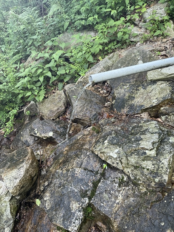
It was .4 miles (so almost an extra bonus mile that doesn’t count today) and it took 15 minutes to walk down the very steep trail. I sat by the flowing pipe a while and drank over a liter of cold, fresh water until my stomach hurt, and filtered and filled my bottles so I was carrying 2.5 liters back up the steep trail. The round trip took almost an hour, and I was the last person down and up. It was about 5:30 by then. The things out here that make me realize how much I take for granted in modern life.
I set up my tent in a nice spot, if a little rocky, but no dead trees around finally. Gadget and Ironheart set up next to me, and we talked about our town experiences and I showed them how the Far Out app works while I ate dinner. It was couscous mixed with a packet of chicken and the last slice of cheese from Ray and Michele.
I had really wanted the Backpacker’s Pantry vegan stew, but it was 2.5 cups of water to cook, which was not happening without a water source close by. That water will have to last me to the shelter tomorrow at least, because I’m not making that trip again in the morning. Plus I didn’t need more liquid; my bladder was already making its feelings known about how much I had drank at the spring. But hey, the water I drank was water I didn’t have to and couldn’t carry up with all my bottles full.
It was 7:00 when I was done with dinner, and although I had stopped 6 miles short of my goal today, I am perfectly okay with that. I’d budgeted extra miles to get to DWG by Thursday, but thanks to Squeak and Dave feeding me dinner last night, and Jeff and Shawn’s generosity with snacks, I had enough food to get there on Friday if I need to. I will go as slow out of PA as I have to if it means I arrive in New Jersey safe and healthy.
Tomorrow and Wednesday it is supposed to cool down, with some rain and storms. I’m looking forward to the cooler weather and just hope my shoes don’t get too wet.
All day I wondered if PA blues a thing for flip floppers? I think they might be. PA is a long state on the trail that I thought before, 234 miles if I am calculating right. Most NOBOs by now are cranking out the miles, regular 20s or around there. They get through PA much faster time-wise than flip floppers would, if most flip floppers are smart (unlike me) and really take their time in the beginning. Technically, I should be a bit further south right now.
People say the Virginia blues are a thing, because Virginia is over 500 miles on the trail, but that is considering most NOBO hikers already have their trail legs by then. If they are going twice as fast as flip floppers, would it make sense that could happen to us in PA?
I started in southern VA last time and absolutely loved all of my time in Virginia, I didn’t get the blues that I can remember, even taking longer there than most people. It’s harder elevation wise, but the rocks in PA can be demoralizing at times up north.
It’s been interesting to see how southern PA flew by for me and the last 60 miles of this state have been such a slog, ever since I tired myself out and starting hitting the parts that give “Rocksylvania” it’s nickname. I know lots of NOBO hikers who maintained 20+ mile days through those gnarly rocks, though. How much faster that experience would be for them than the flip flop group.
Not to mention, Altras are ultralight minimalist trail runners that were the top used shoe by successful thru hikers last year, but they really don’t make for a great supportive shoe for someone just starting out and then hitting the rocks. I guess I would recommend to future flip flop hikers to choose sturdier shoes to start, and maybe even consider starting somewhere in VA like I did the first time. I had very light trail runners through all of Virginia and never had a problem that I can remember, and I was able to do big miles through that state with much less pain because there aren’t rocks like that all the time.
It’s really cool to me that I can compare two separate flip flop attempts and see what worked better and what didn’t, and how each is already so different compared to NOBO and SOBO. I thought I might regret not going terminus to terminus this time, but I think I like the familiarity that actually comes for me with doing it this way.
I’m also especially excited to see what the rest of the process actually looks like. I already know how it feels starting somewhere in the “middle”, but what does it feel like hiking all the way to the northern terminus? Traveling back to the starting point, three months later, and probably feeling like a totally different person than the one that arrived there to start the journey. Then hiking south, when (by that point) for 2,000 miles on the AT over seven years, I’ve 99% of the time always traveled north? Then finally ending my hike at the southern terminus, and walking down to the Amicalola Falls arch, where I have really special memories already.
PA is probably my least favorite state of the AT so far, which is common for thru hikers, but I’d still rather be here right now than anywhere else. It’s like the worst of the best. I have so many amazing parts of the AT to visit and revisit this year, and I’m honesty glad to be getting such a hard state over with early, PA blues or not. So that’s a pro for the flip flop hikers who start in Harper’s Ferry. Get PA over with early, and leave it behind, becoming a stronger hiker for it. Almost there.