
Carl Newhall Lean-to 2115.7 to East Branch Lean-to 2126.5 (10.8 miles, 1,101.1 total miles)
It poured for hours through the night, but I managed to sleep very well regardless, getting a whopping 10 solid hours of rest. That, plus the fact that I’d stopped hiking at 1:45PM the day before, had me feeling quite rested.
I hadn’t wanted to set an alarm, since it was a full shelter. I figured people usually get up early in shelters and start making noise, which would wake me up. It was a risk, since I am a very heavy sleeper once I’m out, but it had worked fine the last couple mornings at the hostel.
I woke up at 6:40, and saw the guy who’d been sleeping next to me was up and moving. I slid my mattress over, and started thinking about getting up, figuring I’d try to hit the trail by 8AM.
The rain had tapered off for the most part, though drops were falling steadily from the trees. I had pop tarts, Belvita breakfast cookies, Starbucks instant coffee, and a carnation to start my day.
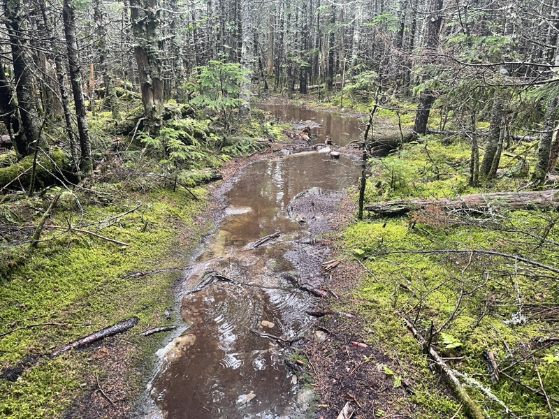
Honeybadger, Wicked, and Einstein hiked out before me as well. I’d put on dry socks, but quickly realized that was a mistake as I began hiking and saw the trail was just one big stream, and even a river in some places.
It was a mile up to the first mountain, Gulf Hagas, and it took me 40 minutes to get there, going slow to start the day. After .8 of an easy downhill, I got to the campsite where Sunshine had spent the night, and had a gently graded 700 foot ascent up to West Peak.
I found I had enough service to send and receive texts on West. I saw Halfway had summited Katahdin, though I wasn’t sure if it had happened today or yesterday.
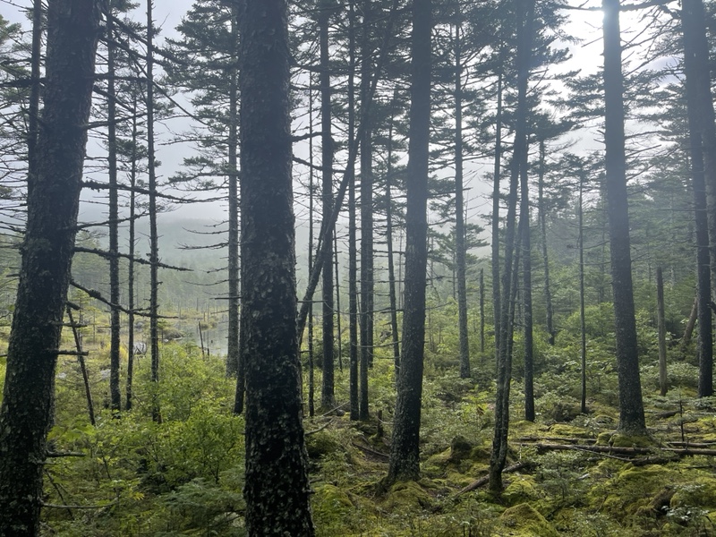
It was great to see, and I continued down and up Hay Peak. In between the mountains, the water on trail got very deep, and I tried to skirt around the edges, brushing by lots of wet trees in the process.

It had resumed raining rather early in the day, and stayed steady as I hiked. I passed the section hiker who’d gotten up first this morning on my way up Hay, then caught Einstein and Wicked at the summit.
I hung out with them for a few minutes, then continued on around 10:30. The trail was slick from all the rain, and I’d slid down a rock and fallen hard on my butt earlier.
Other than that, I was actually enjoying myself, in a masochistic sort of way. The fact my tent was dry in my pack made everything better, even though rainwater was steadily dripping off the tip of my nose.
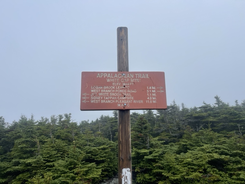
Up and over White Cap, with stone steps on both sides got me a couple miles away from the shelter where I was going to break. White Cap was totally socked in and windy, which was unfortunate because that is generally the first view of Katahdin for those going northbound.
The rain picked up as I was making my way 1.4 down the steep climb from White Cap. I saw a few other hikers going south, and passed Honeybadger on the way.
I kept slipping and falling on wet roots when I was almost at the shelter. I could hear Logan Brook raging below me for quite a while before getting to the lean-to, and the rain had definitely picked up.
I got there at noon, wrung out my rain jacket which had been keeping my pack quite dry on top, and started snacking.
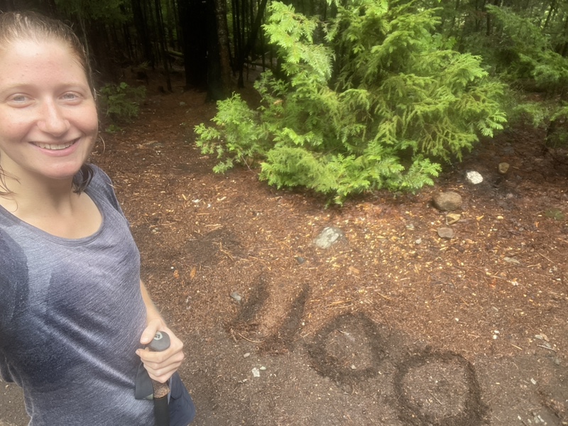
Honeybadger got there a few minutes later, and we sat chatting. He is from Wisconsin and had previously hiked the AT, now was sectioning with Einstein and the crew. I realized while we were talking I’d hit my exact halfway point on the AT for my hike just .4 before the shelter.
I had a blueberry Promeal bar and a bag of Fritos, and I never knew corn chips could taste so good. The water at the brook was raging when I went down to fetch a liter, and Wicked and Einstein arrived in the meantime.
While I was using the privy, a SOBO had arrived and warned everyone about the river we needed to ford ahead. Wicked started to get anxious about it, and Einstein and Honeybadger talked about the “chain method” of crossing.
I figured I’d see if Sunshine was at the shelter right before the crossing or not, and decide what to do from there. We are about the same size, and if she made it across I was sure that I could.
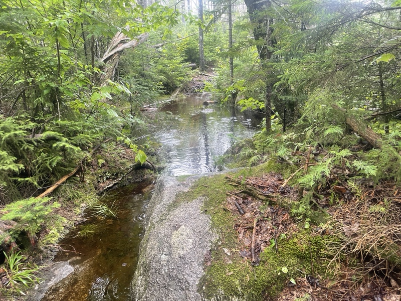
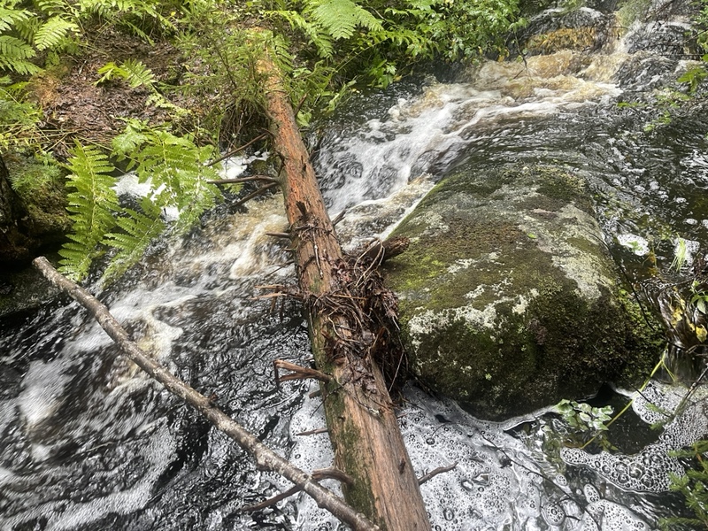
I passed the road after the shelter, where Wicked said she was going to wait for the others to figure out what to do. After the road, the trail turned into a lagoon in a couple spots, and I had to ford the trail itself under several inches of water.
A little further on, an unmarked water source had turned into a raging mini river cascading down the mountain, and I found a log down the way to cross over.
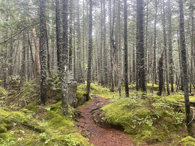
After that, the trail became beautiful for a mile and a half of green mossy forest floor, with large boulders protruding out of the dense greenery.
The rain stopped for the most part, besides a light drizzle. I saw blueberries on either side of the trail for a while, and stopped to pick a third of a quart bag full of them. If my day was about to get very stressful with the river, I wanted something to cheer me up.
I arrived at East Branch Lean-to around 3, and turned the corner to see Sunshine set up in the shelter like she was in for the evening. I swore aloud when I saw her.
I clarified I wasn’t upset to see her, I was upset that she hadn’t made it across the river. Sunshine told me that she’d gone down and looked at it, and knew there was no way she could make it across.
She was planning on staying at the shelter for the night and seeing if the water went down in the morning. I wasn’t so sure it would be any better in the morning, based on how much water was collected on the trail itself, and cascading down the mountains into the river.
She mentioned a 6 mile road walk detour, which included the 2 miles back to the road we’d just crossed. Honeybadger arrived and said he was going to hike the .2 to the river and check it out.
While he was gone, Wicked and Einstein arrived. Pharmadillo was supposed to come out to the next road and bring the others a food drop. We thought maybe he could shuttle us to the following road.
I was good with the road walk, but we didn’t have the right maps on our phones that we could figure out which logging roads to follow, and really didn’t want to get lost in backwoods Maine.
Honeybadger came back soaking wet, because he tried to scout out a couple spots. He showed us a video of the water in the river just absolutely raging with the current.
Sunshine said she’d watched a couple people cross, taller guys who’d almost fell in. She said one of the men was six feet tall and the water came up to his waist. At a foot shorter, it would be coming up much higher on us.
There were also deep drop off spots where the rope to ford was, that you couldn’t see under the water and didn’t know where they were.
I definitely felt like trying to cross was unsafe, and I didn’t have enough food or time to wait out the water at the shelter for a couple days. The reservation at Baxter had been extremely hard to get, and there weren’t going to be any others to switch days.
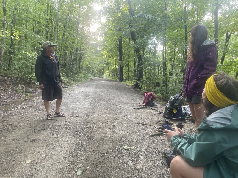
We used Sunshine’s Garmin to send a message to Pharmadillo, and waited a while to see if he’d respond. We were thrilled when he did, and got ready to hike 2 miles back to the original road.
The sun almost came out a couple times on our way back, and when we got to the road it started raining again. Pharmadillo had to meet Longshot first at another road, so we waited a couple hours for him to arrive.
As we were waiting, we decided to get a ride back to Shaw’s with Pharmadillo, since he was staying there, if he was willing to drive us back to the trail in the morning.
The idea of being able to dry my soaked socks and get town food did it for me. Pharm pulled up in his crew cab heavy duty truck, and we managed to cram all the packs in the bed, and seven of us in the cab, since Longshot had the same idea.
When we were driving down the road, I found out we had an almost two hour drive back to Monson. By then it was already 7PM, so I just went with it.
We saw a moose running down one of the logging roads, though it disappeared before we could get too close.
Finally we arrived on pavement, and a little later got cell service. We called Shaw’s to let them know we’d be arriving late and seeing if they had tenting space.
Poet couldn’t have been more accommodating, and we also called to order pizza at a gas station near the hostel. We picked up the pizza at 8:45PM, and drove right around the block to Shaw’s.
Poet came out to greet us, and I was relieved to find that there were plenty of people still up, sitting by the fire and in the common room. I’d been worried about disrupting anyone by arriving so late.
Poet couldn’t have been nicer, and he urged us to relax, take hot showers and do laundry if we wanted. Sunshine and I had split a pizza, and I downed most of my half before setting up my tent on the wet lawn.
I took a very hot shower, loving the feeling of hot water falling on me after being hit by cold water all day. I also threw my wet stuff in the dryer, not having the energy to actually wash any of it.
I ran into Two Braids and Percy when I was checking if my clothes were dry, and was really happy to see them. I spent a few minutes catching up and telling them about our experience.
I finished my pizza in the common room, and hung with a couple SOBOs. They were 10 days into their hike and about to take their first zero. It was so fascinating that they were in such a different place than all the NOBOs I’d been around.
I turned in late, around 10:30, and watched a little Stranger Things before falling asleep. I never would have expected that I’d be bailed out halfway through the 100 Mile Wilderness.
I’d gotten incredibly lucky to meet Einstein and his crew. When I tried to give him money for the pizza, he’d refused to take it, and told me, “welcome to the trail family”. Somehow I’d joined a third family in only 1100 miles.
It really bothered me that I’d had to skip 4.7 miles of the trail. I had been adamant this time that I wasn’t going to skip anything, and had stayed true to that till now.
Feeling unsafe would be the only reason I’d consider that, and I never expected something like this on the AT. The PCT and CDT often have fires or snow that require reroutes, but the AT is generally very safe.
We hadn’t gotten rain almost the entire summer, till suddenly we’d had multiple days of rain. Apparently something like three inches had fallen the other evening, and I wondered what the other fording rivers I’d already passed looked like now.
I knew I wanted to make up the miles, but it was the absolute worst place on trail to try to do so. To access that point, it was an almost two hour drive from both Shaw’s or Katahdin.
Unfortunately, I didn’t have the time at the moment to hike the 5 miles south from the next road back to the river, and then rehike it north with the miles I needed to do to meet Ashley on the 21st. It wasn’t a risk that made sense to take.
So I’d have to try to figure it out, and decide what I could and couldn’t live with. It looked like that was the last river ford of the 100 Mile, so I felt like that wouldn’t become an issue again. I hoped I’d have a better idea of what to do in the morning.